

Results 31 to 60 of 239
Thread: Irma
-
09-05-2017, 04:52 PM #31Fab Five

- Join Date
- Aug 2012
- Posts
- 26,291
Irma
Good news bad news... if it does take that northward turn at Miami, the farther up the peninsula it goes the weaker it'll get. The other good news is more than likely it'll be moving faster than say Harvey so there won't be the 50" rain totals.
I've got several friends in and around Doc's area and they're all very nervous and they all have different plans. Some fleeing some staying... all of the ones on Hutchison Island are leaving, some more inland are staying.
Sent from my iPhone using Tapatalk"I have touched all the so-called capitals of basketball, but when it gets down to the short stroke, the only true capital of basketball is in Lexington." AL McGuire
-
09-05-2017, 05:52 PM #32Fab Five
- Join Date
- Aug 2012
- Location
- Radcliff, Ky.
- Posts
- 33,879
Re: Irma
A Cat 5, you leave and vacation in the Bluegrass
Before I leave Id like to see our politics begin to return to the purposes and practices that distinguish our history from the history of other nations,
I would like to see us recover our sense that we are more alike than different. We are citizens of a republic made of shared ideals forged in a new world to replace the tribal enmities that tormented the old one. Even in times of political turmoil such as these, we share that awesome heritage and the responsibility to embrace it.
-Patriot and Senator. John McCain
-
09-05-2017, 07:08 PM #33Fab Five
- Join Date
- Aug 2012
- Location
- Bowling Green, KY
- Posts
- 44,512
Re: Irma
+10,000,000 Originally Posted by kingcat
 seeya
seeya
dan
I'm just one stomach flu away from my goal weight.
-
09-05-2017, 07:09 PM #34Fab Five
- Join Date
- Aug 2012
- Location
- Bowling Green, KY
- Posts
- 44,512
Re: Irma
Hurricane Andrew 1992
 seeya
seeya
dan
I'm just one stomach flu away from my goal weight.
-
09-05-2017, 07:16 PM #35Fab Five
- Join Date
- Aug 2012
- Location
- Bowling Green, KY
- Posts
- 44,512
Re: Irma
 seeya
seeya
dan
I'm just one stomach flu away from my goal weight.
-
09-05-2017, 07:23 PM #36Administrator
- Join Date
- Aug 2012
- Posts
- 43,256
Re: Irma
Where is that Dan?
People keep asking if I'm back and I haven't really had an answer. But now, yeah, I'm thinkin' I'm back.
-
09-05-2017, 07:36 PM #37Administrator
- Join Date
- Aug 2012
- Posts
- 2,613
That has to be Homestead.
-
09-05-2017, 07:43 PM #38Administrator
- Join Date
- Aug 2012
- Posts
- 43,256
Re: Irma
Duh, yeah, looks like it.
It's not like most of my friends in Key West have much in the way of means. It's so expensive to live there. They make good money as their jobs go, mostly I know bartenders (no surprise), and most rent and don't own, but still. I do know several there who own too, but this one may get all the way up Solares Hill. It's the highest point on the island, and it should be OK from the surge, but obviously not so much from 150+ mph winds blowing tree trunks and everything else across the island.
Of course all of Florida is at risk in this one. I think this is going to go pretty badly.People keep asking if I'm back and I haven't really had an answer. But now, yeah, I'm thinkin' I'm back.
-
09-05-2017, 07:46 PM #39Fab Five
- Join Date
- Aug 2012
- Location
- Bowling Green, KY
- Posts
- 44,512
Re: Irma
Yup Originally Posted by Darrell KSR
seeya
dan
I'm just one stomach flu away from my goal weight.
-
09-05-2017, 07:57 PM #40Administrator
- Join Date
- Aug 2012
- Posts
- 43,256
Re: Irma
Just checked some of the webcams in Old Town. Still some folks there, but nothing like normal of course. People are heading out. Tourists have to be out tomorrow, bet that will be fun at the airport.
But honestly I'm surprised how many are still there even though it's maybe a fifth of what is typical for this time of year. Probably waiting on flights later in the week to get out I assume.
Almost no cars. The people who drove down are heading out, these are the folks waiting for flights.People keep asking if I'm back and I haven't really had an answer. But now, yeah, I'm thinkin' I'm back.
-
09-05-2017, 08:01 PM #41Administrator
- Join Date
- Aug 2012
- Posts
- 43,256
Re: Irma
As an aside I've considered if we moved there getting a boat b/c if a storm comes you gas up and leave. Head up to the panhandle or Atlantic side depending on the direction.
Cost wise you can buy something pretty cheap used. The only problem is the slips there are as expensive as the land and I don't know the first thing about boats. OK, I know they should keep the water out and stuff, but not sure what to do when that doesnt' happen.People keep asking if I'm back and I haven't really had an answer. But now, yeah, I'm thinkin' I'm back.
-
09-05-2017, 08:07 PM #42Fab Five
- Join Date
- Aug 2012
- Location
- On the South Bank of the Cahaba River
- Posts
- 20,815
Re: Irma
Doc, Good Luck! I'm becoming increasingly concerned that this damn thing id going to enter the gulf. If it gets there it will become difficult to predict.
Real Fan since 1958
-
09-05-2017, 11:25 PM #43Administrator
- Join Date
- Aug 2012
- Posts
- 43,256
Re: Irma
Well, Sloppy Joes, Hog's Breath, have all shuttered at midnight it looks like. That's usually just getting started time. Streets are deserted, everything just about shuttered up (good news is Key West buildings have built in shutters due to the obvious need periodically). Everyone heading out.
People keep asking if I'm back and I haven't really had an answer. But now, yeah, I'm thinkin' I'm back.
-
09-06-2017, 12:34 AM #44Fab Five
- Join Date
- Aug 2012
- Location
- On the South Bank of the Cahaba River
- Posts
- 20,815
Re: Irma
Very sad Citizen. As of Late Tues Night, the majority models show it now will get to the keys and head north, most likely through the center of the peninsula or up the Atlantic Coast.
Real Fan since 1958
-
09-06-2017, 06:53 AM #45Fab Five
- Join Date
- Aug 2012
- Location
- Jupiter, FL
- Posts
- 43,087
Re: Irma
Looks to be that some think its going to stay south and west of us, make it to the gulf. Im going to start shuttering up this afternoon though
Last edited by Doc; 09-06-2017 at 09:09 AM.
Aging is an extraordinary process where you become the person you always should have been.--David Bowie.
-
09-06-2017, 09:48 AM #46Administrator
- Join Date
- Aug 2012
- Posts
- 2,613
Re: Irma
-
09-06-2017, 10:07 AM #47Administrator
- Join Date
- Aug 2012
- Posts
- 2,613
Re: Irma
-
09-06-2017, 10:17 AM #48Administrator
- Join Date
- Aug 2012
- Posts
- 2,613
Re: Irma
Doc, Suncat--this looks even worse to me (for you guys). Please be careful.

-
09-06-2017, 10:56 AM #49Administrator
- Join Date
- Aug 2012
- Posts
- 43,256
Re: Irma
Heading right for my beloved Keys. They'll get through it, they've endured it many times, but still hate to see it.
People keep asking if I'm back and I haven't really had an answer. But now, yeah, I'm thinkin' I'm back.
-
09-06-2017, 11:41 AM #50Fab Five
- Join Date
- Aug 2012
- Location
- Bowling Green, KY
- Posts
- 44,512
Re: Irma
NHS is still in a quandary as to where Irma will go, when it will turn, etc. I think it will be sometime Friday before they can pretty much pin down the track. Irma wants to turn north for sure, but the question is when and where will the door be when it opens for Irma.
seeya
dan
I'm just one stomach flu away from my goal weight.
-
09-06-2017, 12:58 PM #51Bombino
- Join Date
- Aug 2012
- Location
- Kirkland, WA
- Posts
- 2,805
Re: Irma
I have been keeping track of the details of the storm via the http://reddit.com/r/TropicalWeather they have a daily thread that monitors all scientific updates from this storm. If you go to that thread, set the sorting to new (to get newest messages first) and you will get almost realtime updated data and analysis by the users. There was some really interesting data last night. One of the most important being that this storm basically cancelled its Eye Wall Regeneration Cycle. Typically, the storms will regenerate their eye wall every so often and during this time, the storm weakens or maintains strength. Last night, all signs were there pointing to a new eye wall being established soon. The new eye wall was showing structure inside the storm, the old one was showing signs of weakening, etc. Pretty much textbook EWRC, until it just stopped. Nobody knows why, nobody was even sure if this was known to have happened before. Of course, with the cancelled EWRC, the storm kept strengthening overnight, dropping down to 913 mbar. This was very unexpected, today things are a bit better as the mid-level wind sheer that Irma ignored yesterday is making its presence felt today. The eye is less organized and the pressure has risen to 922 mbar (which is still a remarkably strong storm, but at least it isn't strengthening). This is still a catastrophically strong storm, just not quite as catastrophic as it was at 2AM EDT last night.
Watching the models evolve has been very interesting too. GFS has overall been a bit more accurate initially, but Euro is rapidly falling in-line with GFS. Both GFS and Euro have been very squirrely, lots of wobbles in their predictions and a good amount of variation in the ensembles indicating a LOT of uncertainty (more on that later).
As for what the models are predicting on where it will go:
Now for a bit of good news, bad news, worse news, even worse news. There have been some really scary model runs that occurred last night, with some models indicating possibly sub-880mbar pressures after strengthening (a few models even had it at sub 870-mBar). This would make it one of the most powerful, if not the most powerful, storms to ever exist in the Atlantic. The good news: These seem to have let up some due to the aforementioned weakening. The bad news: those models predicted a heavy strengthening followed by a, more or less, rapid collapse. They anticipated a weak grazing of Florida, followed by a weakening and eventual landfall at either strong CAT 3 or CAT 4. The new models don't have the storm getting that strong but anticipate it making a Cat 5 landing in the Miami-Dade area. Worse news: The new models indicate an 895 mBar pressure when it hits the Miami head-on. This would put it in the Top 5 Atlantic storm of ALL TIME (landfall or not) and within spitting distance of the Top 3 ("Labor Day" Storm was recorded at 892 mbar). Additionally, this would put it as either number 1 or number 2 of strongest Atlantic hurricane to make landfall ever (depending on if it drops below the 892mBar recorded for the Labor Day storm when it landed)! Even worse news: It is expected to retain its Cat V status until it rehits land somewhere between SC and VA.What are the likeliest scenarios?
East coast of Florida Landfall or Brush - Trending slightly up this morning. Both operational model runs are showing this right now, and it is well within their respective model ensembles.
Miami and South Florida Landfall - Holding steady this morning. It is the likeliest path in the center of the National Hurricane Center cone. Model runs have flip flopped between east and west of this location for the last couple of days and the NHC still maintains this is the center-line to follow. The Euro, the most reliable model, has most ensemble members going through this location.
West Coast of FL Landfall - [Trending slightly down this morning, but still in the top possibilities. It wouldn't take much for the models to shift back to a West Coast of FL Landfall, and it is very much within the cone.
Georgia Landfall[/B] - Trending slightly up this morning. If we get an east coast landfall or brush, many ensemble members and at least one operational run takes this storm into the Savannah area.
South Carolina Landfall - Trending up this morning. The Euro model run AND GFS model run both take the storm here. It is well out of the NHC cone because it is simply too far away right now, but I would be highly paying attention to this scenario.
North Carolina Landfall - Holding steady this morning. Yesterday we had a GFS operational run at 18z that took the storm into Wilmington, so the option is still open. It is not the likeliest scenario but it is also a long time from now. I would very much be paying attention in Wilmington.
Gulf Coast and Panhandle - Trending slightly down this morning after a ton of ensemble runs showed a Gulf entry yesterday. Ensemble members have shifted east, and even the western ensemble members hook it back into Florida.
That being said, this storm is so large and powerful, as I mentioned, the models are having a hard time getting a handle on it with a lot of uncertainty. We just don't have enough data on storms of this scale to make accurate models and forecasts. We can extrapolate from weaker storms but extrapolation only gets you so far. You can extrapolate how well a drag racer can perform but if your data is mostly Kia Rio's and Honda Accords, your estimate isn't going to be very good. That's kinda where they are with this storm. As such, a lot of the predictions will change dramatically over the next 48hours, as it has in the past 48-72h. Because of this rapid change, even if the models don't show it hitting your area, you are still at risk and should take basic precautions.
-
09-06-2017, 01:06 PM #52Administrator
- Join Date
- Aug 2012
- Posts
- 2,613
Re: Irma
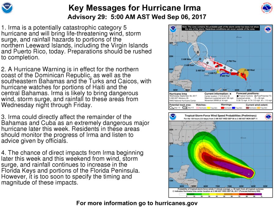
2 pm advisory....

-
09-06-2017, 01:08 PM #53Administrator
- Join Date
- Aug 2012
- Posts
- 2,613
Re: Irma
Great info, Pedro. Originally Posted by PedroDaGr8
Hopefully all affected will heed your advice in the last sentence. It has the potential to be really devastating to human lives.
-
09-06-2017, 04:37 PM #54Bombino
- Join Date
- Aug 2012
- Posts
- 2,424
Re: Irma
Just got through building a house in Hilton Head. Just got done furnishing the house last week. Was planning on going down after the game Sat. for a couple of weeks and go to the game. Just put the hurricane shutters up and hoping for the best.
-
09-06-2017, 07:57 PM #55Administrator
- Join Date
- Aug 2012
- Posts
- 43,256
Re: Irma
Even if it goes that way they're predicting it will diminish to Cat 3 or so. NOt good of course, but not nearly so bad as it is right now. Originally Posted by truecatsfan
That's if it diminishes of course. You never know about these things.People keep asking if I'm back and I haven't really had an answer. But now, yeah, I'm thinkin' I'm back.
-
09-06-2017, 08:13 PM #56Bombino
- Join Date
- Aug 2012
- Posts
- 2,424
Re: Irma
What that they told me today was they are worried about the surge. Giving fifteen feet, that will put the island under water. Originally Posted by CitizenBBN
-
09-06-2017, 09:20 PM #57Administrator
- Join Date
- Aug 2012
- Posts
- 43,256
Re: Irma
Makes sense. Hopefully that will be much lower as well. Originally Posted by truecatsfan
On several of the keys 5 feet will be enough, including a fair amount of Key West. Solares Hill is the highest point and it's about 18' above sea level. most of the island is more in the 5-10 range.
if this thing hits as a Cat 5 they're saying the surge could be 15-25 feet. It could completely wipe out the island, even Solares Hill. The last time it was hit anything like this bad was 1935.
In general Key West has dodged the bad ones. There are many stories as to why, I prefer to think God knows his children need a place to take a break.
Hopefully this one will turn out to sea sooner than they expect and miss all of us.People keep asking if I'm back and I haven't really had an answer. But now, yeah, I'm thinkin' I'm back.
-
09-06-2017, 09:37 PM #58Administrator
- Join Date
- Aug 2012
- Posts
- 43,256
Re: Irma
Checking around the webcams on the island. Schooner's Wharf is still open. Not busy, but a few folks there at the bar. But that bar serves a lot of marina folks, I wonder if that's why, and they're going to boat on out Friday or so if it keeps looking bad.
People keep asking if I'm back and I haven't really had an answer. But now, yeah, I'm thinkin' I'm back.
-
09-06-2017, 09:59 PM #59Fiddlin' Five
- Join Date
- Aug 2012
- Posts
- 5,889
Re: Irma
-
09-06-2017, 10:12 PM #60Administrator
- Join Date
- Aug 2012
- Posts
- 2,613
Irma
Wow. Originally Posted by Catonahottinroof


 Reply With Quote


Bookmarks